
Before satellites, before aircraft, before any technology capable of seeing the Earth from above, human beings were already trying to understand the full shape of the world they inhabited.
The maps they produced in that effort tell a story far more fascinating than any single geographic discovery, they reveal how civilizations thought, what they feared, what they believed, and how the boundaries of human knowledge expanded over thousands of years.
The earliest of these maps were not inaccurate out of ignorance or carelessness. They were honest representations of the world as each civilization experienced it.
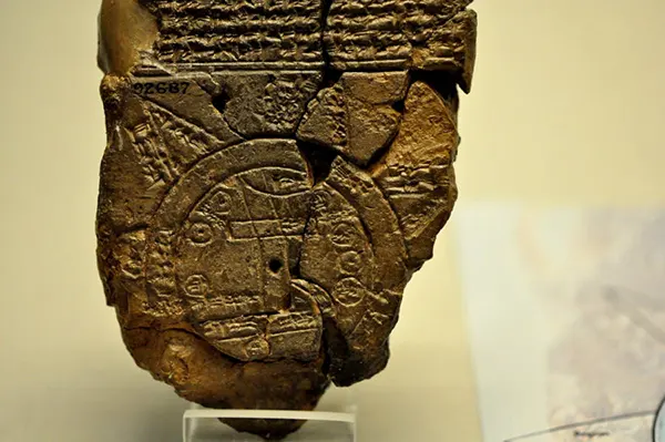
The oldest known world map dates back to 6th century BC Babylon. It places Babylon at the center of existence, with the known world stretching no further than the borders of Mesopotamia. A circular “bitter river” surrounds everything, beyond which lie seven islands thought to be forever out of reach.
When the Babylonians drew the oldest known world map more than 2,500 years ago, they placed their own empire at the center and let the known world taper off into bitter, impassable waters beyond its edges. Their map was not wrong to them; it was complete. It showed everything they knew.
For many early civilizations, the world was understood as a circular disc surrounded by ocean, its surface divided among three landmasses: Europe, Asia, and Africa.
Over centuries, that picture slowly filled in. Greek geographers pushed the boundaries outward, northern Europe took shape, Britain appeared on the edges of the known world, and cautionary notes crept into the margins warning that life could not survive beyond certain southern latitudes.
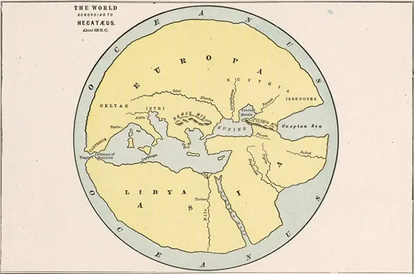
Greek historian Hecataeus of Miletus produced his world map sometime in the 5th or 6th century BC, dividing the known world into three regions — Europe, Asia, and Libya — all oriented around the Mediterranean Sea.
Maps were growing more accurate and more ambitious until a different kind of authority stepped in. As Christian theology gained influence over European scholarship, cartographers increasingly set aside geographic observation in favor of biblical structure.
The world came to be shown as a perfect T shape, divided into three parts and anchored at its center by Jerusalem.
The Garden of Eden appeared as a real location. Gog and Magog were marked as actual places. For several centuries, the map of the world was less a geographic document than a statement of faith.
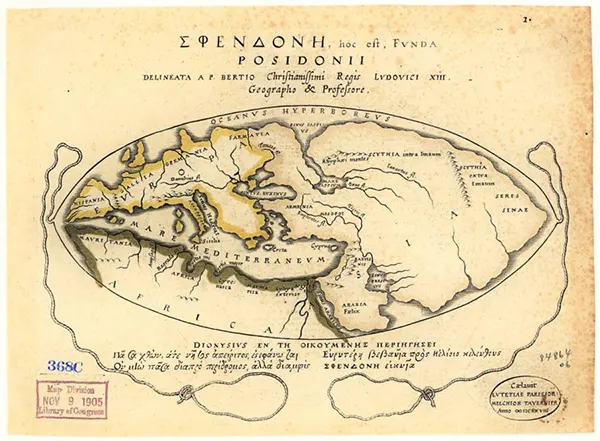
The philosopher Posidonius drew his world map in the 2nd century BC, building on earlier Greek geographic traditions and incorporating the territorial discoveries made during Alexander the Great’s campaigns.
The age of exploration in the 15th century broke that framework open. European traders and navigators began pushing east with new ambition, and the maps they produced started to reflect a far more detailed picture of Asia, including China, Mongolia, Korea, and Japan.
Meanwhile, Chinese cartographers were undergoing their own revision, expanding the small, marginal space they had long assigned to Europe into something closer to its true scale.
Two entirely separate traditions of mapmaking were converging, however slowly, toward the same world.
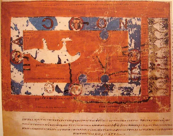
Roman geographer Pomponius Mela produced his world map in 43 AD, offering one of the earliest surviving Roman attempts to chart the known world.
In 1492, the year before Christopher Columbus returned from his first Atlantic voyage, the oldest surviving globe was produced in Germany.
It showed a spherical Earth with a vast, unbroken ocean where the Americas would soon be found. Within a few years of Columbus’s return, that empty ocean began to fill.
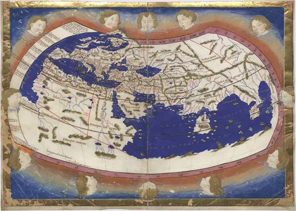
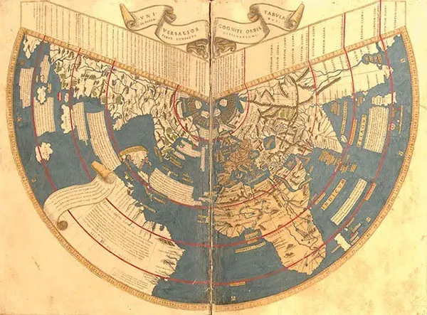
Claudius Ptolemy’s world map, completed around 150 AD, was groundbreaking for its introduction of a coordinate system using lines of longitude and latitude — the first time such a grid had been applied to a world map.
The New World appeared first as a thin strip of coastline, then as a continent, and the maps of the world began taking on a shape that, for the first time, resembles what we recognize today.
Australia and New Zealand emerged from the blank edges of the map, the polar regions were gradually charted, and by the late 18th century, the outlines of the world were finally, fully drawn.
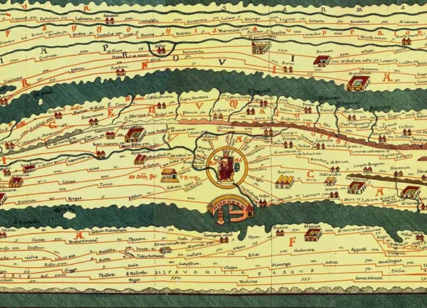
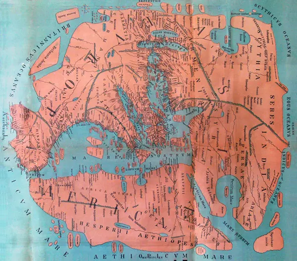
The Tabula Peutingeriana, a 4th century Roman map, charts the vast road network of the Roman Empire. Extraordinarily elongated in shape, it stretches from Iberia to India, with Rome positioned at the heart of the known world.
The 6th century monk Cosmas Indicopleustes mapped the world as a flat rectangle, with the sky arching above it like a vaulted chest and the heavens presiding over all. His cosmology rejected the classical spherical model entirely in favor of a biblical framework.
Isidore of Seville developed the “T and O” map in the 7th century, a design that neatly partitioned the world into three equal sections — Asia, Europe, and Africa — arranged around Jerusalem as the world’s central point.
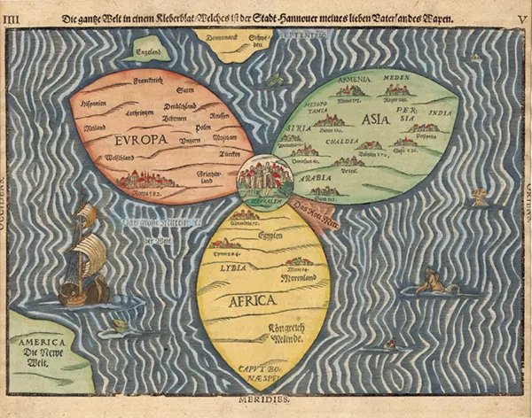
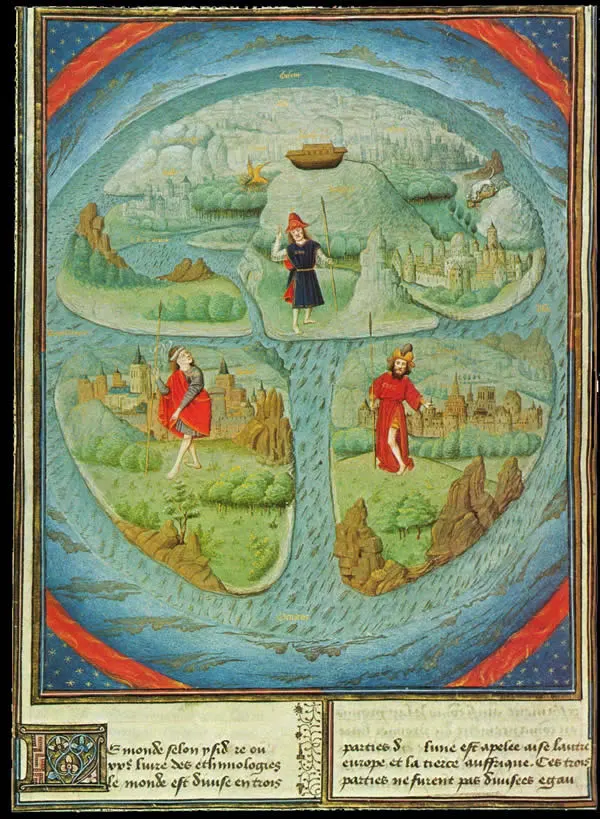
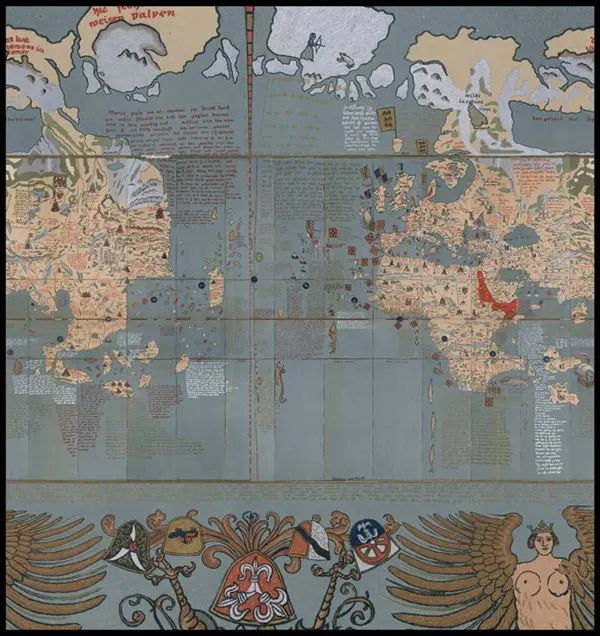
Heinrich Bünting’s Clover Leaf Map, published in Germany in 1581, was never intended as a geographic document. Instead, it visualized the world as a symbol of the Christian Trinity, with three landmasses arranged like petals around Jerusalem, which anchors the composition at its center.
The Anglo-Saxon Cotton Map, produced between 1025 and 1050 AD, orients the world with the east at the top. Its most striking feature is the rendering of every river in Africa in red — a misreading of written accounts describing the Red Sea.
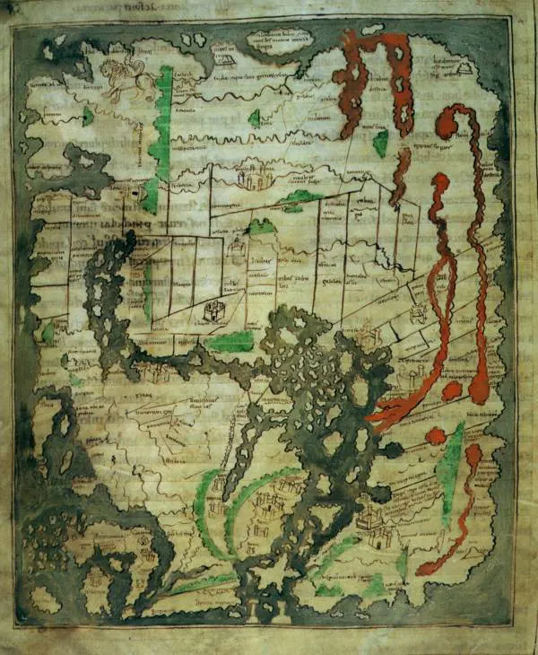
The world map attributed to Beatus of Liébana, an Asturian monk, was created in the 8th century AD as part of his commentary on the Book of Revelation, blending geographic knowledge with biblical geography.
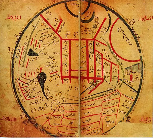
Mahmud al-Kashgari’s 11th century map places the ancient city of Balasagun — in present-day Kyrgyzstan — at the center of the world. Beyond the known territories, the map also charts places tied to eschatological prophecy, including the legendary regions of Gog and Magog.
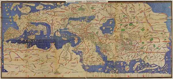
Al-Idrisi’s Tabula Rogeriana, completed in 1154 AD, was compiled from the travel accounts of Arab merchants who had journeyed across much of the known world. It stood as the most accurate and geographically comprehensive world map of its time.
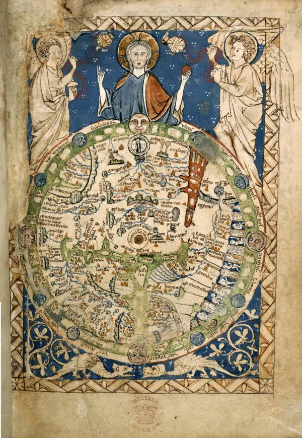
The Psalter World Map, created by an unknown monk in 1260 AD, follows the medieval convention of placing east at the top — toward the rising sun — with Christ depicted overseeing the world from above.
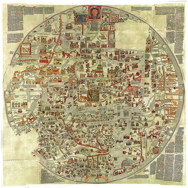
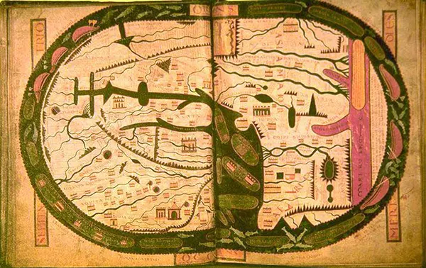
Gervase of Ebstorf’s world map, drawn in 13th century Germany, adheres to the medieval T and O tradition, positioning Jerusalem at the center and organizing the continents around it in the established tripartite scheme.
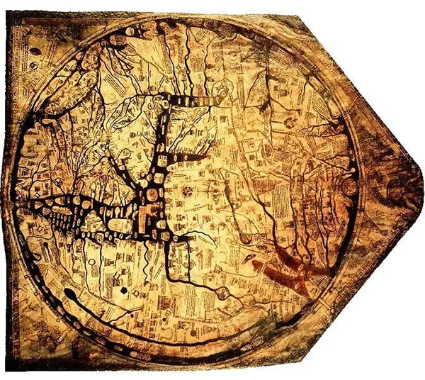
Richard of Haldingham’s Hereford Mappa Mundi, produced in the 14th century, is another T and O map with Jerusalem at its center and east at the top. Notably, it places the Garden of Eden as a physical location at the map’s southernmost edge.
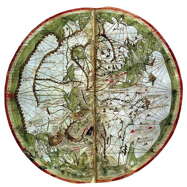
Venetian cartographer Pietro Vesconte’s 1321 world map marked a turning point in geographic accuracy. By incorporating nautical charts — tools of practical navigation — he reintroduced precision to world mapping after centuries dominated by the symbolic T and O tradition.
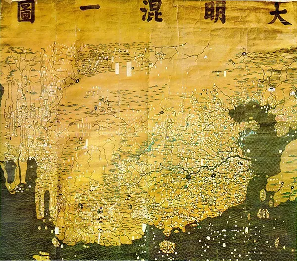
The Da Ming Hun Yi Tu, produced in late 14th century China, reflects the world as understood during the Ming Dynasty. China commands the vast majority of the map’s surface, while the entirety of Europe is compressed into a small corner of the west.
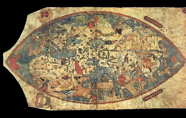
The Genoese Map of 1457, drawn from the accounts of Venetian traveler Niccolò da Conti, reflects Europe’s expanding knowledge of Asia following the opening of overland trade routes through Mongolia and China.
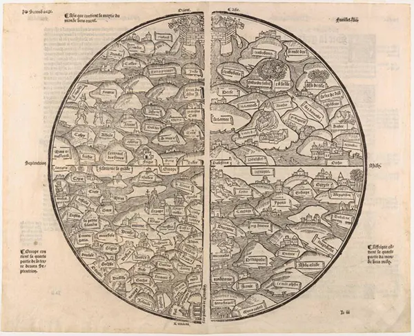
The Mer des Hystoires world map, produced in 1491, shows that even on the eve of the Age of Exploration, some cartographers — particularly monks — continued producing T and O maps, with Jerusalem at the center and the earthly paradise positioned as a real, physical place in the east.
Martin Behaim’s Erdapfel, crafted in Germany in 1492, is the oldest surviving globe. It accurately represents the Earth as a sphere, but with one conspicuous absence: the Americas, whose existence was yet unknown, appear simply as open ocean.
Johannes Ruysch’s 1507 world map is among the earliest to depict the New World in cartographic form, capturing the first tentative efforts to understand and represent the lands Columbus had encountered.
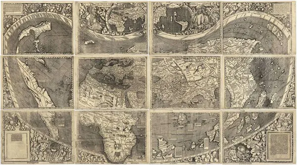
Also produced in 1507, the map by Martin Waldseemüller and Matthias Ringmann was the first to apply the name “America” to the New World. At this stage, the continent appears only as a narrow sliver of coastline — the eastern edge being all that European explorers had yet seen.
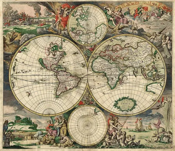
By the time Gerard van Schagen produced his world map in 1689, the outlines of most of the globe had been charted. Only scattered portions of the Americas remained uncertain, left deliberately vague where knowledge had not yet reached.
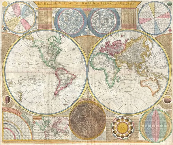
Samuel Dunn’s 1794 world map drew heavily on the voyages of Captain James Cook to produce what was, at the time, the most complete outline of the world ever committed to paper — the first map to account for the full shape of the globe.
(Photo credit: Wikimedia Commons).